Donard Challenge Mountain Race
Northern Ireland Round of the
British Championship.
Registration
Donard Park, Newcastle,
The Start, Registration, parking, toilets & Showers can be
found at Map Ref: 373306
Start will be at 12 noon
ENTRIES
Entry £10 by 21st March using the online entry system.
Teams free
If possible, please use the online entry system as it integrates with our results system. Alternatively, you can enter by post using the form available on the website. Please pre-enter as this helps our race administration. While entries can be made on the day, the cost is £13.
A list of race entries will be published on the web site.
COURSE – 10 km 900 metres climb (Cat: Short).
START: – Donard Park. Map ref. 373306
Checkpoint 1:- Quarry/ Wall (Drinneevar) 300m. Map ref. 376287
Checkpoint 2:- Millstone Mountain summit 460m. Map ref. 373285
Checkpoint 3:- Slieve Donard summit 850m. Map ref. 358277
Checkpoint 4:- Quarry/ Gate. Map ref. 371293
Finish: – Donard Park. Map ref. 373306
The Mournes Activity map 1: 25000 or Harvey Mourne Mountains map cover the route.
(All checkpoints must be visited in order)
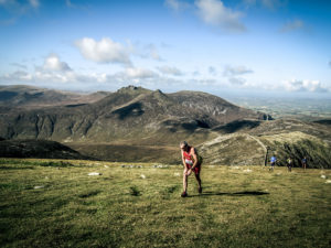
THE COURSE IN PICTURES.
INTRODUCTION.
“Where the Mountains of Mourne Sweep Down to the Sea “so goes the well known song by Percy French.
What better way to describe the setting for this year’s British Championship Mountain Race?
This is a new course designed to provide a testing short mountain race specifically for the 2014 British Championship Series starting and finishing in Donard Park, Newcastle, Co. Down.
At 10k with over 850m of climbing taking in Millstone mountain before climbing to the summit of Slieve Donard 850m ( the highest mountain in Northern Ireland ), then descending all the way to the finish in Donard Park at sea level. This should make your journey well worthwhile and satisfy the most discerning fell runner.
COURSE DESCRIPTION.
The race starts at sea level in Donard Park and follows the forest road across the Donard Bridge then taking the rough cobbled path on the south side of the Glen River before turning south-east using the forest paths to reach Checkpoint 1. Ascend on rough steep ground to reach Checkpoint 2 Millstone Mountain summit. After making a short descent off Millstone you then make the main climb to the summit of Slieve Donard. Underfoot the ground is mostly heather turning to grass with patches of boulders as it steepens towards the summit. You will first see the lesser cairn which is 250m before and 30m below Checkpoint 3 (at the large summit cairn), beside the tower at the corner of the Mourne Wall. From here the route is downhill all the way to the finish at sea level, the section to Checkpoint 4 to the small gate at the edge of the quarry/ forest is a mixture of boulders, heather and grass with stony patches becoming steeper with some rock when approaching the forest/ quarry. Take care on descent if conditions are misty you will need a compass bearing as the ridge is both broad and deceptive. From here take small marked paths through Donard Wood on the south side of Glen River into Donard Park and finish.
The sections of the race course from the start to checkpoint 1 and from Checkpoint 4 to the finish will be marked.
ACCOMMODATION
There are plenty of B&Bs, guest houses and self catering cottages in the region, with Newcastle the main centre. Newcastle has a Youth Hostel and there is a well appointed campsite at Tollymore Forest Park.
Meelmore Lodge on the north side of the Mournes (grid ref 305 307) has a basic campsite, showers and a café.
Other accommodation details are available from Tourist information offices:-
Central Promenade Newcastle
Co Down
BT33 0AA
tel: 028 4372 2222
fax: 028 4372 2400
e-mail newcastle@nitc.net
Tollymore Campsite 028 4372 2428 Meelmore Lodge 028 4372 6657
Websites www.kingdomsofdown.com Newcastle YH 028 4372 2133
www.downdc.gov.uk
E-mail info@kingdomsofdown.com
TRAVEL
By air you can travel to Belfast City and International airports. Easyjet fly to Belfast International & BMI to City.
You can travel to Belfast and Larne by ferry from Cairnryan and Troon
Also Dublin/Dun Laoghaire from Holyhead. Stena, P&O and Seacat all operate services
P&O 0870 24 24 777 Stena 08705 70 70 70
www.poirishsea.com www.stenaline.co.uk
MAP
Both the Mourne Country Outdoor Pursuits Map (LPS) and the Harvey Mourne Mountains map 1:25,000 cover the area of the race route.
PRIZEGIVING
A finger buffet is provided as part of the entry fee at the prize giving. The prize giving will be held at the Race Centre following the event.